WORKSHOP 1
ARMANDO DAL FABBRO
with ERNST STRUWIG, JEAN-PIERRE BASSON, SHEREE MARINUS
PROPOSAL FOR A MIXED USE DEVELOPMENT COMPRISING THE BAAKENS RIVER MOUTH TO THE SEA, ST PETER’S CHURCH, CEMETERIES, PROPOSED PEDESTRIAN BRIDGE AND EAST SEA BORDERING HISTORICAL AREA OF SOUTH END
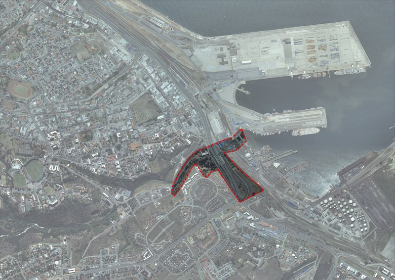
The aim of the project is to create a special place of remembrance, a heritage resource and a visitor destination (tourism). This important heritage site of South End includes the ruins of St Peter’s Church, St Mary’s Cemetery, The Malay Cemetery, the Pauper Cemetery and the demolished east sea bordering historical South End, subject to forced removals in 1965 and presently occupied by the freeways, the Masjied Ul Aziz Mosque and a wild fig tree.
The Baakens river is prone to flooding, affecting properties in the Baakens Valley and a second canal is proposed to address this urgency. It is suggested to remove all or some of the existing bridges at the Baakens River outlet to the Port and propose a solution of connecting this important node of converging movement systems to the CBD (Central Business District) and historical centre of the city. This includes the proposed new pedestrian bridge linking the banks of the Baakens river providing pedestrian connections to the CBD and whole area adjacent to the old Electric Tramways building, recently restructured as the headquarters of the MBDA (Mandela Bay Development Agency). The existing Union street parking area below the freeway providing parking for the MBDA, inner city and visitors to the heritage areas, with safe pedestrian connections, has to be taken in consideration.
The St Peter’s Church ruin is located adjacent to the St Mary’s Cemetery. The stone church was built in 1876 and was the first “daughter church” of St Mary’s which was established in 1871. St Peter’s served the Anglican community residing in South End. After the forced removals by the Nationalist Government, the church was de-consecrated in 1972. This landmark church has slowly been destroyed through vandalism and theft. This ruin needs to be taken care of as it is of great significance in terms of the cultural and religious history of South End and therefore noteworthy in terms of the intangible cultural heritage of the area.
St Mary’s Cemetery (or Episcopal Cemetery) was originally the military burial site, however it became the Anglican cemetery from 1825. The cemetery, as with the St George’s cemetery, was closed in 1898. The cemetery is in a very poor state and is subjected to vandalism and theft and needs attention.
The Malay Cemetery was granted to the Muslim community in 1855. Very little of the original site remains.
The Pauper Cemetery is on the north of the complex adjacent to Valley Road. The site of the old Electric Tramways building possibly contains a Pauper’s Cemetery. Various sources related to the 1908 and 1909 floods refer to the possibility of convicts executed at the various goals in the city and paupers were buried on the south bank of the Baaken’s River. This site was never recorded on maps.
The Black Steps, in need of restoration, on the west of the complex forms part of the heritage assets, which are part of the remnants of the old South End pedestrian footpath of which the date is unknown.
With the first plots of land of South End, historically known as “the place beyond the river”, being sold in 1859 to the Muslim Community followed by people from diverse Communities such as Khoi, Fingo, Xhosa, European, Indian, Chinese, etc. the need for civic and religious buildings became necessary. St Peters Church situated at the top of the cemetery, overlooking the Baakens river and sea, became the first religious structure to be realised in South End. Prior to the establishment of South End, the Muslim Community had already two mosques in Central, Port Elizabeth. Next to St Peters Church stood a tall cross, which could be seen when out on the sea and which was used by the fishermen (mostly Muslims) as a beacon to leave or return from their fishing trips.
South End subsequently developed into a vibrant and flourishing cosmopolitan suburb with a steadily growing and diverse population who lived in mutual respect and harmony with a strong communal identity. With businesses and retail activity along its residential streets, its Community became known for its artisanal skills and its entrepreneurial abilities. A strong economic, cultural and religious integration and a mutual dependency were established between suburb and city.
On the 10th of May 1965 the first expropriations were sent out to the Community by the Nationalist Government, which implied the forced removal of 8,742 inhabitants. Over the following 16 years South End was demolished slowly in phases with only a few buildings remaining: the Masjied Ul Abraar Mosque, the Masjied Ul Aziz Mosque, a Dutch Reformed Church, the Seamans Institute (now South End Museum), the South End Workers’s Houses and the Upper Valley Road ”Shri Siva Subramanier Aulayam” Hindu Temple.
“The worst memory I have of South End, however, is the day we left; that very last time I closed the door of my home, not looking back; never to return. We left behind almost a hundred years of family memories” Yusuf Agherdien.
It is the intention of the MBDA to return a part of this important heritage site to its former activities, which played such a decisive role in the economic, cultural and religious life of shaping the development and history of the city. This is an aspect that the proposed project can take in consideration.
The landscaping of the proposed project should be an integral part of the project relating to the Route 67 concept of which it will form part.
For more information about Prof. Armando Dal Fabbro click here
Workshop Homepage